Wednesday, August 23, 2017

Map: Why Where

I asked my students a couple trick questions today.  Some of them caught them, but most students were tricked.  ...I did warn them that they were trick questions.

They went something like this:

When looking at a map of the world, what continent or ocean is in the center?  The north? The south? What continent is on the east of the map? The west?  The top?  The bottom?  Why?

Some of those questions have definitive answers, but the majority of the answers are: it depends.  Why does it depend?  Because the earth is round, of course.  So, we can split the map along the Pacific Ocean, like this:


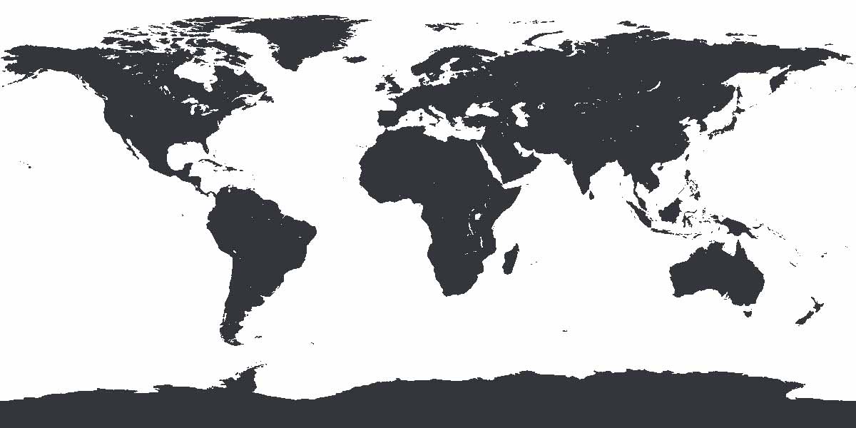
As you can see, Africa is in the middle.  But we could also split the map through Asia, like this:


Now we have North and South America in the middle.


Hopefully you get the idea.  That was the first trick.  There's no continent or ocean that's at the center of the map.  And it's the same with top and bottom.  Although all of these maps show the Arctic Ocean at the top, and Antarctica and the Southern Ocean at the bottom, they don't have to:


The earth is a sphere orbiting the sun.  There's no up or down.  We're just used to seeing north as up, and south as down.  So, the top and bottom of the map can change.  However, the north and south haven't changed.  Although the South Pole is now at the top of the map, it's still the South Pole.  Antarctica is still in the south.  Only now, we'd have to say, "up south," rather than "down south."


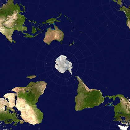
I think this last image makes the point even more clearly.  The South Pole is in the middle of the map.  It's not the top, or bottom, but it's still the South Pole.

Students can get extra credit by reading and discussing this blog with an adult.  To prove they did this, they should write 3 sentences about their discussion, and have the adult sign the paper.  Students: make sure your name, date, and hour are on it, and put it in the extra credit tray tomorrow.

!!!!BONUS: If you want, feel free to check out the videos we watched in class today.!!!


Chaos

*EDIT*  I'm not even joking... this was Tuesday's post.  Somehow it didn't go through.  So, two posts tonight.  :)

The first time we break out the computers, it's always a little chaotic.  I want my students to know how to check their grades and missing assignments, and I want them to be able to do that early.

They should all have that information now, but unfortunately the information wasn't enough to get them logged on.  Give us a couple more days.

They also logged onto google classroom and figured out a couple ways to get extra credit - including this blog.  The other way was by playing the online geography games.

They've got a quiz coming up, and those geography games should help.  The quiz (it's actually a retake, because nearly everyone failed it) will be Thursday.  It's over the continents and oceans.  If students want some more practice learning these, they can practice HERE for even more extra credit.

If you stopped by the blog, list the continents and oceans on a scrap of paper.  Have the adult you read the blog with sign the scrap of paper.  Put your name, date, and hour on it.  Turn it in tomorrow in the extra credit tray.

Sunday, August 20, 2017

Social Studies Gets Eclipsed

I told my students on Friday that social studies is a lot.

It's where you are: geography.

It's when you are: history.

It's who you are: anthropology, cultural studies, religious studies, humanities... history...

It's where you will be, and who you will be.

It's not really what you are.  That's science you're thinking of.  Yeah.  You're thinking of science.

But on Monday August 21st, 2017, science will eclipse social studies.

So, I'm sure students will be focused on the sun.  But on Friday we started in on the earth.  I had the students draw a map of what they thought the world looked like from memory.  Then, we looked at political and physical maps, and they had a chance to draw it again while looking off one of those.

Physical Map: Shows land forms such as mountains, plains, rivers, deserts, etc...

Political Map: Shows man-made  human designated boundaries.

And we gave a bad definition for continents, and then watched this video explaining why the definition was bad.


I see the lessons in that video show up from time to time.  For instance, I was on Facebook last night and saw a fight break out between several trolls over whether or not Columbus discovered America.


Those people need to watch the video.  That's the cause of the confusion, and the reason for the fight.  It seemed like the majority of people on the thread had no idea that much of the world calls North and South America together, "America."

So, welcome to the blog.  Here's how it works.  If one of my students reads this blog with an adult, and they discuss it, the student can get extra credit.  They have to get a scrap of paper and write a few sentences explaining 1: that they read it, 2: who they read it with, and 3: a point or two they discussed.  If they have the adult sign the paper, they can turn it in for 5 points extra credit.  BAM!  That easy.

I'm looking forward to a great school year.

*EDIT*

Also, there's this: