Showing posts with label maps. Show all posts

Wednesday, August 23, 2017

Map: Why Where

I asked my students a couple trick questions today.  Some of them caught them, but most students were tricked.  ...I did warn them that they were trick questions.

They went something like this:

When looking at a map of the world, what continent or ocean is in the center?  The north? The south? What continent is on the east of the map? The west?  The top?  The bottom?  Why?

Some of those questions have definitive answers, but the majority of the answers are: it depends.  Why does it depend?  Because the earth is round, of course.  So, we can split the map along the Pacific Ocean, like this:
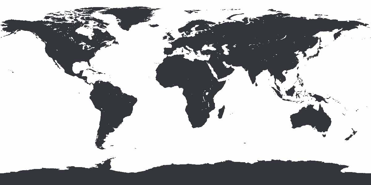

As you can see, Africa is in the middle.  But we could also split the map through Asia, like this:


Now we have North and South America in the middle.


Hopefully you get the idea.  That was the first trick.  There's no continent or ocean that's at the center of the map.  And it's the same with top and bottom.  Although all of these maps show the Arctic Ocean at the top, and Antarctica and the Southern Ocean at the bottom, they don't have to:


The earth is a sphere orbiting the sun.  There's no up or down.  We're just used to seeing north as up, and south as down.  So, the top and bottom of the map can change.  However, the north and south haven't changed.  Although the South Pole is now at the top of the map, it's still the South Pole.  Antarctica is still in the south.  Only now, we'd have to say, "up south," rather than "down south."
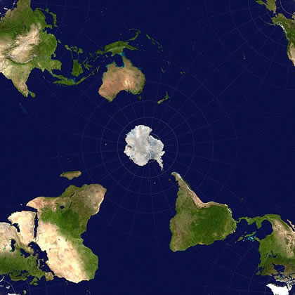

I think this last image makes the point even more clearly.  The South Pole is in the middle of the map.  It's not the top, or bottom, but it's still the South Pole.

Students can get extra credit by reading and discussing this blog with an adult.  To prove they did this, they should write 3 sentences about their discussion, and have the adult sign the paper.  Students: make sure your name, date, and hour are on it, and put it in the extra credit tray tomorrow.

!!!!BONUS: If you want, feel free to check out the videos we watched in class today.!!!


Tuesday, October 20, 2015

TKWA

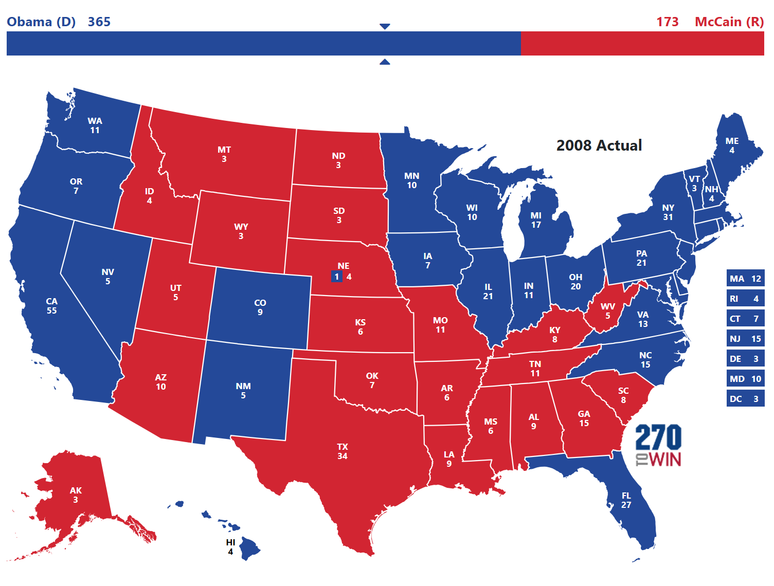
The bellwork today asked students to TKWA a map.

This map, actually:

2008
Barack H. Obama (D) 
Electoral 365
Popular 69,456,897
John S. McCain (R)
Electoral 173
Popular 59,934,814
D (Democratic)
R (Republican)


TKWA is all about order.  When students are answering questions about a map (or a chart, or graph, or newspaper article, or whatever...) they often jump right into the questions.  I tell them they should always look at the title first.  Always.  Read the title.

If the map they're looking at doesn't have a title, move to the key.  Look at the key second.

Third, ask yourself: What is the point?  What is the purpose of this map?

Only after a you do these simple things should you go on to answer the questions.

If students want extra credit for reading and discussing the blog with an adult, they should find a map online and TKWA it.  Maybe google image search "world map interesting" or something.  Have the adult you TKWAed the map with sign the paper.  Make sure your name, date, and hour are on it.  Turn it in in the extra credit tray tomorrow.  See you then.

Monday, August 24, 2015

Map Distortion

I hate liars.  Well, I mean... I don't hate them, hate them.  But I don't like when people lie to me.

Or when maps lie to me.

But, basically every map is telling at least a little lie.

Today we noticed that the earth is measured in degrees.  (We noticed this exact same thing last week.)  And the distance between the degrees differs depending on where you are.  If you're standing on the Equator, 1 degree is nearly 70 miles.  If you're standing on the North Pole, it's less than an inch.

And all those degrees at the north and south get stretched out, distorting most maps we look at.

To show what I meant, we watched a couple videos.  Feel free to check them out here:


Students can earn extra credit by reading and discussing this blog with an adult.  If you've done that, find a scrap of paper and write the phrase, "Maps are lying liars."  Then, students should have the adult they read the blog with sign the paper and turn it in tomorrow.  (They should also make sure their name, date, and class period is written on there somewhere.)


Thursday, August 21, 2014

Distortion: Maps, Latitude, Longitude

We're still working on some basics of geography: Equator, Prime Meridian, the poles, the hemispheres, and of course, latitude and longitude.  The bellwork reviewed some of those basics.

After the bellwork, we watched a couple videos dealing with maps, and map distortion.  They are very good, as well as short.  If you want to watch them again, or parents... if you want to watch them for the first time, here they are:


It's still strange to think that all of those maps are as accurate as the Mercator Projection...  And I've been teaching this for years.

Here's the other one.  I think that Hank Green drinks 5 Red Bulls and 5 Monsters before he makes these videos.  Dude... ... ...  Slow down.  You're speaking too fast.  The frames can't catch you when you're moving like that.    It's very, very good - albeit fast:


The students also had a chance to retake their continents and oceans tests.  Many improved their scores.  Don't forget that you can always go online and see their grades.

I don't know how long it took you guys to read the blog... but to get the extra credit today, it'll take you another... I don't know... 5 minutes...  Have the adult you read the blog with watch one of the two video clips.  (Or both, if you're so inclined...)  When you've finished watching it, ask them what they thought.  Then, find a scrap of paper, and write down 2 things they found interesting.  (The student has to write down the two things.)  Have the adult that read and watched sign the paper.  Turn it in tomorrow.

Until then, have a great day!

P.S. If any of you have social media, would you remind your fellow students that they can get extra credit by going here?  If you share the link, maybe they'll share in the points.

Friday, April 12, 2013

Holy Test on Wed, BATMAN!

On my way to school this morning I heard that the ORIGINAL Batman costume worn by Adam West had made it's way to Elkhart.  If that isn't a piece of awesome news, I don't know what is.  You can check it out at the Hall of Heroes Museum.  (Here's an article too, if you want to read it.)


In far less exciting news, my classes have a test coming up on Wednesday.  You may want to consider studying for it over the weekend.  Study the review guide.  You may also consider playing the online geography games - there will be some questions over countries in the Middle East, continents and oceans, and maybe a couple others as well - China, India, South Africa, Japan, Egypt...  You'll want to know where those are.

If you want extra credit for reading and discussing the blog, play THE MIDDLE EAST three times, and play THE WORLD twice as well. It might be fun to challenge the adult you're reading with.  Their turns can count if you stay there while they play.  Write down or print out your score and have the adult you read and discussed the blog with sign it.

Have a great weekend, people.