Showing posts with label latitude and longitude. Show all posts

Monday, January 25, 2016

Stations! Stations, Everyone!

Ancient Civilization Quiz grades will be entered soon.  If students weren't here on Friday, they should make up the quiz on Wednesday.

Today and tomorrow we're working on stations.

In past years, I haven't done as good of a job as I've wanted reviewing throughout the year.  That changed today.  Around the room, I made 7 stations.  Students had a little over 10 minutes to complete each one.

Almost all of them focused on something we had studied earlier in the year.

Here's a picture from each
Station 1:  Globalization, Industrialization, Urbanization

Wednesday, September 2, 2015

Big Maps to Globes

We're still piecing together how latitude and longitude works, and how to find it.  Why it looks different on a flat map from a globe.

Today we broke out the globes and marker boards.  I gave students a set of coordinates, and they had to figure out the country.  It went well.

You should know that I sent a paper home that explains what's going on with The Hunger Games.  Make sure to read it, fill it out, and return it tomorrow.

Here are some pictures from today's activity.  I hope you enjoy them.

Using the Globes

Using the Globes

Using the Globes

If you want extra credit for reading and discussing the blog with an adult, you should have explained how the game we played went.  Write me a note telling me which picture was your favorite - that will prove you were actually here.  Have the adult sign the paper - that will (kindof) prove that you read the blog with them.

Make sure your name, date, and hour are on it, and turn it in tomorrow.

Tuesday, September 1, 2015

Big Maps: Scale, Time Zones, International Date Line

Our bellwork today dealt with latitude and longitude again.  I felt pretty good about how quickly the students could tackle it.  Of course, some are still struggling.  Either way, they should be prepared to take a little quiz within the next week or so.

International Date Line
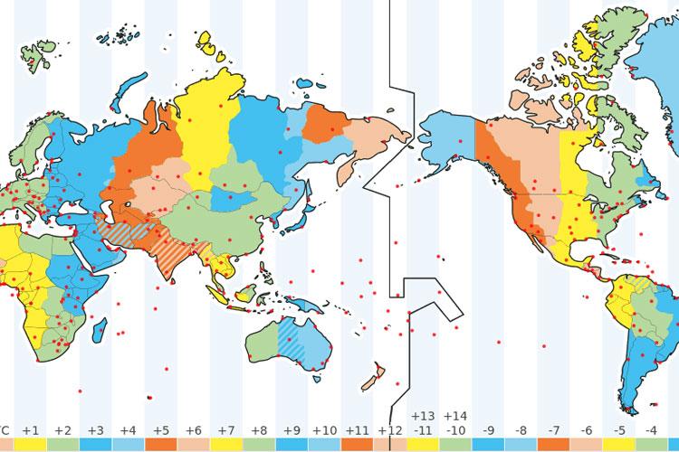
After bellwork, we broke out the Big Maps.  One of the questions asked why the International Date Line zigged and zagged so much.  Why wasn't it just a straight line of longitude like the Prime Meridian.

I didn't have a single student who could answer that question.  So, we looked at it.  Most of my students couldn't tell me how many time zones there are in the world, (24), or why there are 24.  So, we spent some time talking about day and night.  Hours in a day.  Days in a year.  In most classes, I used the flashlight from my phone to represent the sun.  The earth was rotating on its axis and revolving around it.

I think the students understood, after we worked through it.  Either way, count on a bellwork tomorrow that asks questions dealing with time zones, the earth, the sun, and the International Date Line.

After we finished that, we continued working with the Big Maps.  We figured out the circumference of the earth at the equator, and at 60° N...  And we figured out why their answers were so far off with the 60° N question - even the ones where the students answered correctly.  (The farther north you go, the more distorted a flat map becomes...)

Students can earn extra credit by reading and discussing the blog with an adult.  To prove that you were here today, discuss with an adult why the International Date Line zig-zags so much.  Then, write your answer on a sheet of paper.  Have the adult you read and discussed the blog with sign the paper.

Turn it in tomorrow for extra credit.  Have a great day.

Working With the Big Maps

Monday, August 24, 2015

Map Distortion

I hate liars.  Well, I mean... I don't hate them, hate them.  But I don't like when people lie to me.

Or when maps lie to me.

But, basically every map is telling at least a little lie.

Today we noticed that the earth is measured in degrees.  (We noticed this exact same thing last week.)  And the distance between the degrees differs depending on where you are.  If you're standing on the Equator, 1 degree is nearly 70 miles.  If you're standing on the North Pole, it's less than an inch.

And all those degrees at the north and south get stretched out, distorting most maps we look at.

To show what I meant, we watched a couple videos.  Feel free to check them out here:


Students can earn extra credit by reading and discussing this blog with an adult.  If you've done that, find a scrap of paper and write the phrase, "Maps are lying liars."  Then, students should have the adult they read the blog with sign the paper and turn it in tomorrow.  (They should also make sure their name, date, and class period is written on there somewhere.)


Wednesday, August 19, 2015

Latitude and Longitude: 2015

We're learning about latitude and longitude today, and plotting coordinates.

This is one of the many places math and social studies overlap.  I asked my students how many of them studied geography...  Not too many hands.  Yet, they all knew what a triangle, circle, and square were.

More than that, they know the difference between a right angle, an acute angle, and an obtuse angle.

(Not to be confused with obtuse angel):

Obtuse Angel
It's one thing to know what lines of latitude and longitude are - it's quite another for students to understand how they're determined.

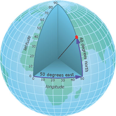
This year, I had them imagine they were floating at the middle of the earth - with a laser.  If they shot their laser straight out - it would be 0°.  If they aimed north at a 45° angle, they would hit the 45° N line of latitude.  If they aimed south 30°, they would hit the 30° S line of latitude.

There are lots of good pictures out there depicting the concept:


We also went over some ways to remember which lines are latitude, and which are longitude.  If you want, you can check out some previous posts about that.  Just click on the "latitude and longitude" link on the side of your screen.  (Or in the drop-down menu, if you're using a mobile device.)

Students can get extra credit if they read and discuss the blog with an adult.  To prove that they did this, have the adult ask the students a question or two - perhaps explain back the "laser from the center of the earth" example of how latitude is determined.  ...Or what is the 0° line of latitude?

Have the students write their answer on a piece of paper, then adults should sign it.

Turn it in tomorrow in the extra credit tray.


Wednesday, September 3, 2014

Continents and Culture - AND LAT LONG VID!!!

So, Mr. Jerlecki's digital media corp finished editing the video footage from our latitude/longitude activity.  You can check it out at the bottom of the post.  I'll talk about it more later... but I wanted to mention it, since I know that is the reason several of you stopped by.


Today we continued our discussion of culture - and what makes a culture.

But we also spent a lot of time on the continents.  Since the majority of students have aced their continents and oceans test, we can spend some time deconstructing all the ideas they have built up during the course of their education thus-far.

If you want to know exactly what I meant, you'll have to watch this video...  We watched it twice:


If you came here to get extra credit for reading and discussing the blog with an adult, you have to read and discuss it with an adult.  ...If you did that - BAM!  You're in luck.  You just have to prove it by writing two sentences telling me whether the adult that read the blog with you also watched the "What Are Continents?" video.  ...If they did (and I hope they did) ask them what they thought about it, and write another sentence telling me what they thought.  Have them sign it.  Then, put your name, date and hour on it, and turn it in tomorrow.  Five free points!!

P.S.  Now, I know some of you are here to see the video from the activity.  The other day we went around the school using latitude and longitude to guide us.  It went really well.  It gauged how well students knew latitude and longitude, but it also showed them how to follow a map.  Like I said at the top, it was edited by Mr. Jerlecki's Digital Media Corp.  That was nice, because it gave me some free time, and allowed them to have added practice video editing.  Win-win.  Check it out if you have time.  Maybe you're even in it!


Thursday, August 21, 2014

Distortion: Maps, Latitude, Longitude

We're still working on some basics of geography: Equator, Prime Meridian, the poles, the hemispheres, and of course, latitude and longitude.  The bellwork reviewed some of those basics.

After the bellwork, we watched a couple videos dealing with maps, and map distortion.  They are very good, as well as short.  If you want to watch them again, or parents... if you want to watch them for the first time, here they are:


It's still strange to think that all of those maps are as accurate as the Mercator Projection...  And I've been teaching this for years.

Here's the other one.  I think that Hank Green drinks 5 Red Bulls and 5 Monsters before he makes these videos.  Dude... ... ...  Slow down.  You're speaking too fast.  The frames can't catch you when you're moving like that.    It's very, very good - albeit fast:


The students also had a chance to retake their continents and oceans tests.  Many improved their scores.  Don't forget that you can always go online and see their grades.

I don't know how long it took you guys to read the blog... but to get the extra credit today, it'll take you another... I don't know... 5 minutes...  Have the adult you read the blog with watch one of the two video clips.  (Or both, if you're so inclined...)  When you've finished watching it, ask them what they thought.  Then, find a scrap of paper, and write down 2 things they found interesting.  (The student has to write down the two things.)  Have the adult that read and watched sign the paper.  Turn it in tomorrow.

Until then, have a great day!

P.S. If any of you have social media, would you remind your fellow students that they can get extra credit by going here?  If you share the link, maybe they'll share in the points.

Tuesday, September 4, 2012

Another Day, A Shorter Prep...

It's crazy that 5 minutes can make all the difference, but I have to cut this post short.  If you're wondering what we did in class today: we looked at some more latitude and longitude problems, played one last game of Latitude and Longitude Battleship, and looked at the globes for a while.

Tomorrow we'll use the globes most of the hour.  We'll see how it goes.

In order to get the extra credit today, plot out the following on the chart below: (10°N, 5°E) and (20°S,15°W).

Parents/Adult reading this, ask whoever you're reading it with how they got to those points.  If they could adequately explain it write: "RIGHT ON!" on a piece of scrap paper and sign it.  If you feel like they couldn't adequately explain it, write: "We'll get em next time" on a scrap of paper and sign it.

Friday, August 31, 2012

Test and Battleship

I don't have that much to say...  I let the kids study for a couple minutes, and then we retook the C & O test.  Everyone did better.  Almost everyone earned an 11/11.  If a student still has an INC, they can retake the test whenever they want.

After that, we played Latitude and Longitude Battleship again.  Yesterday I felt like the kids regressed a little bit on finding coordinates, so we reviewed again before playing.  (Once again, if you go to the link, you can download the file.  Somehow it got changed in the download to mediafire - the lines are messed up and so is some of the kerning.  I hope it changes back when you download it... if not, just blame the teacher.)

I don't want to spoil your long weekend, so I'll keep this post short.

If you want credit for reading it and discussing it, write the following quote on a piece of scrap paper: "In the morning in the winter shade, on the first of March, on the holiday..."  Then, have the adult you discussed it with sign the paper.  (Adult, by signing the paper, you're stating that yes, you really did read and discuss the blog... even if that was only asking how they did on the C & O test, and if they won their L & L Battleship game...  It doesn't mean you have to play them, but if you did I bet their skills would improve.)

Thursday, August 30, 2012

*Whew*

I was really stressing there for a minute.  I couldn't sign into my blog.  There was a technical glitch, but I worked around it.  Go me!

I'm not sure if my students are stressing or not, they have the continents and oceans retake tomorrow.  It would be a good idea to study for it.  Seriously.  I imagine the vast, VAST majority of them will earn 11/11 without having to study much, but it would save us all time if everyone passed.  They wouldn't have to take it anymore.  I wouldn't have to grade it anymore...  You see where I'm going with this...  (*AHEM*)...

We practiced a little bit more today, and then I had the kids draw their second World Memory Map.  They look better than the first.  Yes, this is what we're aiming for.

After that, we played some Latitude and Longitude Battleship.  (Click on the name if you want the directions and a board. *EDIT* I just went to mediafire and noticed that the grid is off... sorry about that.  I think if you download it, the equator should be back to normal... also, some of the kerning.)  I thought it would go a little bit more smoothly than it did.  C'est la vie I guess.  Some classes didn't actually get to play yet.  We'll be trying that out tomorrow after the test.


Friendly students, if you want the extra credit points for the blog tonight, you must read it and discuss it with an adult.  Then, when you've done that, write the following quote on a scrap piece of paper and get them to sign it.  "When Leo Tolstoy was writing War and Peace, his wife Sonya copied for him 7 times."

See you tomorrow.

Tuesday, August 28, 2012

L&L

I think we're getting the hang of this latitude and longitude thing.  Seriously.  I think my students are grasping the concept faster this year than they have any other year.  I don't know why this is...  Either way, I'm happy.

I taught it a little differently this year: the road trip.  Your pencil is the car, your home is 0°N,0°E.  You've got your flaming hot cheetos and your Monster caffinated beverage.  Just start by going North or South.  Once you reach the correct latitude, turn East or West until you arrive at your destination.

We also discussed why we use degrees to measure latitude and longitude.  Bonus points to the student who explains this concept to an adult.

If you want the extra credit points today, students read and discuss this blog with an adult.  Then, adults use the grid below and put your finger on an intersection.  Have the student you're reading the blog with tell you the coordinates.  Do this a total of 5 times.  Then, have them write a set of coordinates on a scrap of paper.  Sign the paper.  He can turn it in for 5 extra credit points.

(You may want to click on the picture to enlarge it.)

Monday, August 27, 2012

C & O test, Lat/Long Practice

In case you're looking at your childs grade, and in case you think: "Uh oh... he went from a really high grade to a really low grade really fast,"  I've got two words for you: calm down.

We did take the Continents and Oceans Test today.  It is a required 100%.  I'll give students more chances to complete the test after we've studied it for a while.

I'd like to point out that it's a 1st grade standard: SS1.3.2 2007.  I won't complain that students don't know it, as long as you don't complain that I'm forcing them to learn it.

We also worked on latitude and longitude practice again today.  This time, the standard came from 7th grade: SS7.3.2 2007 - although latitude and longitude are in there from 4th grade on up, I believe...

Well, if you'd like to get the extra credit points today  - students, you have to read and discuss this blog with an adult - preferrably an adult that you live with.  Discuss means talk about.  Ask questions about.  Questions like: what did you learn about latitude and longitude?  What do you mean, "Mr. Habecker says they shouldn't be called 'lines' of latitude and longitude?"

Then, when you're done discussing.  (Seriously, don't take too long... a minute or two at the most) go to THIS WEBSITE.  It's the blog of a former Concord student who is currently a peace corps volunteer in China.  Find a picture on his website and describe it in a sentence or two.  Have your parent sign that and bring it in.  It seems like a lot, but it really isn't.  And he has some really sweet pictures on there... Like this one, which you can no longer use: