
This is one of the many places math and social studies overlap. I asked my students how many of them studied geography... Not too many hands. Yet, they all knew what a triangle, circle, and square were.
More than that, they know the difference between a right angle, an acute angle, and an obtuse angle.
(Not to be confused with obtuse angel):
 |
| Obtuse Angel |
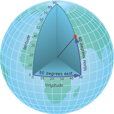
This year, I had them imagine they were floating at the middle of the earth - with a laser. If they shot their laser straight out - it would be 0°. If they aimed north at a 45° angle, they would hit the 45° N line of latitude. If they aimed south 30°, they would hit the 30° S line of latitude.
There are lots of good pictures out there depicting the concept:

We also went over some ways to remember which lines are latitude, and which are longitude. If you want, you can check out some previous posts about that. Just click on the "latitude and longitude" link on the side of your screen. (Or in the drop-down menu, if you're using a mobile device.)
Students can get extra credit if they read and discuss the blog with an adult. To prove that they did this, have the adult ask the students a question or two - perhaps explain back the "laser from the center of the earth" example of how latitude is determined. ...Or what is the 0° line of latitude?
Have the students write their answer on a piece of paper, then adults should sign it.
Turn it in tomorrow in the extra credit tray.
No comments:
Post a Comment