Tuesday, September 1, 2015

Big Maps: Scale, Time Zones, International Date Line

Our bellwork today dealt with latitude and longitude again.  I felt pretty good about how quickly the students could tackle it.  Of course, some are still struggling.  Either way, they should be prepared to take a little quiz within the next week or so.

International Date Line
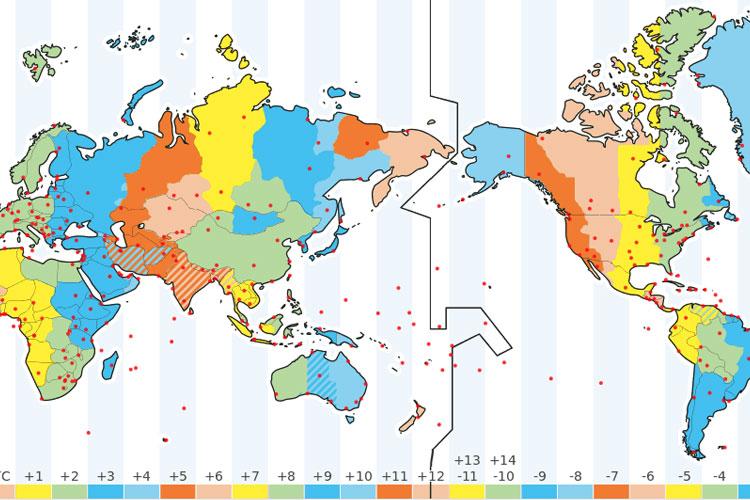
After bellwork, we broke out the Big Maps.  One of the questions asked why the International Date Line zigged and zagged so much.  Why wasn't it just a straight line of longitude like the Prime Meridian.

I didn't have a single student who could answer that question.  So, we looked at it.  Most of my students couldn't tell me how many time zones there are in the world, (24), or why there are 24.  So, we spent some time talking about day and night.  Hours in a day.  Days in a year.  In most classes, I used the flashlight from my phone to represent the sun.  The earth was rotating on its axis and revolving around it.

I think the students understood, after we worked through it.  Either way, count on a bellwork tomorrow that asks questions dealing with time zones, the earth, the sun, and the International Date Line.

After we finished that, we continued working with the Big Maps.  We figured out the circumference of the earth at the equator, and at 60° N...  And we figured out why their answers were so far off with the 60° N question - even the ones where the students answered correctly.  (The farther north you go, the more distorted a flat map becomes...)

Students can earn extra credit by reading and discussing the blog with an adult.  To prove that you were here today, discuss with an adult why the International Date Line zig-zags so much.  Then, write your answer on a sheet of paper.  Have the adult you read and discussed the blog with sign the paper.

Turn it in tomorrow for extra credit.  Have a great day.

Working With the Big Maps

Monday, August 31, 2015

Map Scale

My students are getting pretty good at drawing the world from memory.  We'll see what the pay-off is later.  I didn't give them as much time for that as I was planning.  #Thanks2HourDelay

We spent most of our time together looking at maps of various sizes, and discussing scale.  Although the scale of the maps changed dramatically, the distances between two points on the maps remained the same - because the world itself doesn't change.

Although we didn't have much time, we figured out distances using two different world maps.  

Tomorrow and Wednesday I'm hoping for more time.  Maybe we'll finish up map scale, and latitude and longitude.

I'm keeping the post short today.

Thanks for reading.

Thursday, August 27, 2015

Moving to Maps

We've been focusing on latitude and longitude - but with grids.  We've played Battleship, and placed Louis Tomlinson...  We've denoted the Equator, and the Prime Meridian.

But until today, we haven't looked at it on a map.

I thought the students would just be able to pick it up.  Really, it's the same thing we've been doing for the last week and a half.  ...But for some reason, they found it difficult.

We'll get it though.  I'm confident.  And it won't be long.

We also retook the continents and oceans quiz.  I hope to have those grades in the gradebook by the end of the day.  It wouldn't hurt to check grades.  There are several in there now.

If students want extra credit today, they need to check their grades with their parents (or some other adult.)  Write down your social studies grade on a piece of paper.  Have the adult you read the blog with sign the paper.

Turn it in tomorrow for extra credit.  (Make sure your name, date, and hour are on it.)

Wednesday, August 26, 2015

Battleship: I Crushed It! I Cheated!

I thought I was going to have the students play each other in Latitude/Longitude Battleship yesterday.  But first hour still had a lot of students who struggled with plotting their points.

So, I decided I would challenge the entire class - starting 2nd hour.  I gave them a grid with the ships already drawn on.  They had to plot them.  And then, students used those to play against me.

It's true - I knew where they had their ships.  ...I'm the one who decided where they went.  That led to some students accusing me of cheating.  But, I really didn't cheat until the very end of the game - and then only a little.

My Ships - With Some Notes on How to Plot

The point of playing together yesterday wasn't winning or losing - or whether or not I cheated.  It was making sure my students can plot the points on their own - and then play against each other today.  And they did.  And it went really well.

Students can get extra credit if they read and discuss the blog with an adult.  Students, explain Latitude & Longitude Battleship to the adult you read the blog with.  To prove you've done this,
find a scrap of paper, and write 2 sentences about the discussion.  Then, have the adult you read with sign the paper.

Make sure your name, date, and hour are on it.  Turn it in tomorrow in the extra credit tray.

If you want to play L&L Battleship, you can print off a form for yourself HERE.

We are also grading the Forestland paper tomorrow.  I believe everybody turned it in today.  If you didn't make sure you get a copy.

Monday, August 24, 2015

Map Distortion

I hate liars.  Well, I mean... I don't hate them, hate them.  But I don't like when people lie to me.

Or when maps lie to me.

But, basically every map is telling at least a little lie.

Today we noticed that the earth is measured in degrees.  (We noticed this exact same thing last week.)  And the distance between the degrees differs depending on where you are.  If you're standing on the Equator, 1 degree is nearly 70 miles.  If you're standing on the North Pole, it's less than an inch.

And all those degrees at the north and south get stretched out, distorting most maps we look at.

To show what I meant, we watched a couple videos.  Feel free to check them out here:


Students can earn extra credit by reading and discussing this blog with an adult.  If you've done that, find a scrap of paper and write the phrase, "Maps are lying liars."  Then, students should have the adult they read the blog with sign the paper and turn it in tomorrow.  (They should also make sure their name, date, and class period is written on there somewhere.)